- Home
- Middle East
- UAE
- Khalifa University’s lab uses remote sensing observations to find potential unexplored archeologic ..
Khalifa University’s Lab Uses Remote Sensing Observations To Find Potential Unexplored Archeological Sites In UAE
Fahad Shabbir (@FahadShabbir) Published July 27, 2021 | 05:45 PM
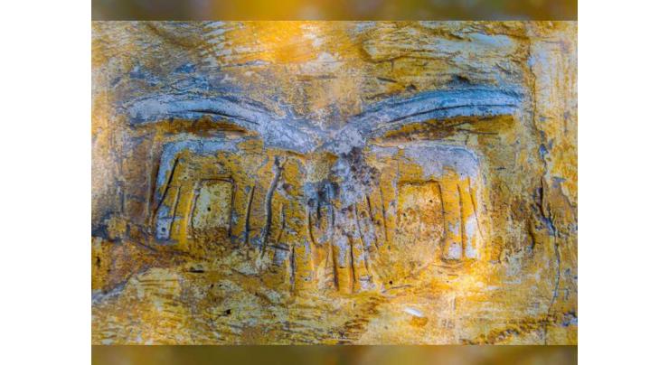
ABU DHABI, (UrduPoint / Pakistan Point News / WAM - 27th Jul, 2021) Khalifa University of Science and Technology has announced that researchers at its Environmental and Geophysical Sciences (ENGEOS) Lab have used satellite remote sensing observations to detect buried objects in already known archaeological sites and to identify potentially unexplored archaeological sites in the UAE by applying machine learning techniques to satellite data.
The novel method, which combines satellite data and machine learning, was developed at Khalifa University and can be applied to similar desert environments in the UAE and elsewhere. With this technology, the researchers were able to find a new potential area, unexplored yet by classic methods. This area is buried under the ground and is located on the opposite side of the current excavations.
Currently, the ENGEOS Lab at Khalifa University is investigating another archaeological site near Al Ain in the UAE.
Results from the ENGEOS research project led by Dr. Diana Francis, head of ENGEOS Lab, show that radar imaging allows direct detection and characterization of known as well as potentially novel buried archaeological sites. Researchers use satellite-borne Synthetic Aperture Radar (SAR) at very high resolution that can detect features of the size of one meter that might be buried in the subsurface (less than two meters) under optimum conditions, that is, dry and bare soils such as the soil at Saruq Al Hadid site. Moreover, remotely sensed data are well-suited for supporting regional archaeology, as well as tracking of environmental factors that influence archaeology.
Based on the machine learning techniques and deep learning analyses conducted during this work, the ENGEOS Lab was able to find potential areas for further on-site investigation. The unsupervised artificial intelligence developed during this project was partially validated as it was able to find the areas already under excavation on the site. As a next step, the method developed during this first phase of the project will need to be validated through a field survey, which will help improve the accuracy of the results.
This technology will not only help reduce the cost of archaeological exploration but will also effectively help archaeologists identify potential locations. At the same, it will create a model that will be more accurate with time, because it has the ability to learn and use this knowledge.
Dr. Arif Sultan Al Hammadi, Executive Vice-President, Khalifa University of Science and Technology, said, "Khalifa University researchers focus their efforts not only on science, engineering, technology and healthcare areas, but also are able to apply remote sensing to archaeology to explore UAE’s cultural and heritage sites. The ENGEOS Lab leads remote sensing at Khalifa University and has developed an archaeology application with the potential to be applied to similar desert environments, anywhere in the world."
The Saruq Al Hadid archaeological site was selected for the first study by the ENGEOS researchers. This site had earlier been investigated by a team of researchers from Dubai Municipality and the Mohammed bin Rashid Space Center (MBRSC) Lab, indicating the presence of buried settlements in the site used by ancient indigenous workers.
Discovered in 2002, Saruq Al Hadid sits deep in the desert of the southern reaches of Dubai emirate and is believed to have been an iron-age metal ‘factory’ in operation around 1,300-800 BC. Even though relics from the Stone Age (10,000 BC) have also been discovered, the peak period of the site is believed to have been around 3,000 BC. Based on up to 12,000 artefacts found on the site, archaeologists believe it is one of the main centers of copper tool manufacturing in the region since the beginning of the Iron Age (1,000 BC).
Dr. Francis said, "Remote sensing has been able to assist archaeological research in several ways in recent years, including detection of subsurface remains, monitoring of archaeological sites and monuments, and archeo-landscapes studies. Now, artificial intelligence and machine learning applied to remote sensing can provide additional support and invaluable guidance for on-site archaeological work.
Recent Stories

Tennis: ATP Barcelona Open results - 1st update
9 hours ago

Swiatek's perfect 10 in Stuttgart as Vondrousova stuns Sabalenka
9 hours ago

Arandu's roads closed due to flooding
9 hours ago

Oil tanker catches fire in Islamabad’s Blue Area
9 hours ago

Pakistan committed to ensure safety of foreign nationals: FO
9 hours ago

Tennis: WTA Stuttgart results - 1st update
9 hours ago

Four passengers injured as train hit an empty vehicle
9 hours ago

Over- speeding bus crushed to death two bike riders
9 hours ago

Turkey's Freedom Flotilla ready to set sail for Gaza
10 hours ago

French teen dies from heart failure after knife attack near school
10 hours ago

Iranians appear unfazed by Isfahan blasts
10 hours ago

UAF celebrates Int'l Chinese Language Day
10 hours ago
More Stories From Middle East
-

UAE announces ‘Zero Bureaucracy Program’ to reduce bureaucracy
3 months ago -
COP28 President-Designate welcomes Transitional Committee agreement to operationalise Loss and Damag ..
6 months ago -
Global Media Congress 2023 to feature Co-Production Majlis as a new networking platform
6 months ago -
Young female athletes shine at Abu Dhabi World Youth Jiu-Jitsu Championship
6 months ago -
King of Jordan receives Abdullah bin Zayed and ministers participating in Arab coordination meeting
6 months ago -
Abdullah bin Zayed participates in coordination meeting of Arab foreign ministers, joint meeting wit ..
6 months ago


-
3rd annual conference of Emirates Society of Clinical Microbiology kicks off in Dubai
6 months ago -
SIBF 2023 hosts Nobel laureate to discuss emergence of ‘Afrofuturism’ in global discourse
6 months ago -
ALC announces winners of Kanz Al Jeel Award 2023
6 months ago -
SIBF turns spotlight on remarkable contributions of women
6 months ago -
Global assets in spot bitcoin ETFs hit $4.16 billion
6 months ago -
Rescuers struggle to find Nepal quake survivors as deaths reach 157
6 months ago


