NASA Launches Delta II Rocket With ICESat-2 Satellite Measuring Ice Level Changes
Daniyal Sohail Published September 15, 2018 | 08:53 PM
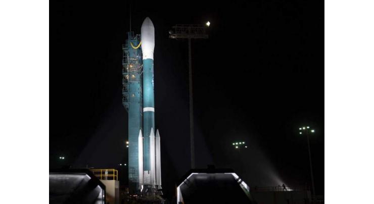
The Delta II US carrier rocket, with NASA's Ice, Cloud and land Elevation Satellite-2 (ICESat-2), set to measure the changing height of Earth's ice, on board, lifted off from the Vandenberg Air Force Base in the US state of California on Saturday, which was broadcast live by NASA.
WASHINGTON (UrduPoint News / Sputnik - 15th September, 2018) The Delta II US carrier rocket, with NASA's Ice, Cloud and land Elevation Satellite-2 (ICESat-2), set to measure the changing height of Earth's ice, on board, lifted off from the Vandenberg Air Force Base in the US state of California on Saturday, which was broadcast live by NASA.
NASA specified that the rocket lifted off at 6:02 a.m. local time (13:02 GMT).
The United Launch Alliance said on Wednesday that this would be the last launch of its Delta II rocket, which was first launched in 1989 and had since then "created a legacy throughout its history" carrying NASA and US military satellites.
The ICESat-2 will gather data tracking changes in the global ice sheets' level via its Advanced Topographic Laser Altimeter System. This will enable researchers to analyze climate change and make predictions on sea level rises caused by ice melting. The ICESat-2 mission is expected to last for three years.
Recent Stories

Masood Khan calls for Pak-US cooperation for regional peace
34 seconds ago

Interior Minister starts Margalla Trail Patrol for security
5 minutes ago

Currency Rate In Pakistan - Dollar, Euro, Pound, Riyal Rates On 26 April 2024
3 hours ago

Today Gold Rate in Pakistan 26 April 2024
4 hours ago

ICC Womens T20 World Cup Qualifier, Match 2: Ireland Women open with Comfortable ..
7 hours ago

Robinson, bowlers help New Zealand go 2-1 up against Pakistan
13 hours ago

Shahzeb Chachar to hold khuli kachehri on April 26
13 hours ago

Heatwave amid Israel's aggression in Gaza brings new misery, disease risk
13 hours ago

Tourism must change, mayor says as Venice launches entry fee
13 hours ago

Court adjourns Judicial Complex attack case till May 17
13 hours ago

Nasreen Noori’s book ‘Popatan Jahra Khwab’ launched
13 hours ago

Wafaqi Mohtasib inspection team visits Excise and taxation office
13 hours ago
More Stories From Technology
-

Punjab CM inaugurates Pakistan’s first Virtual Women Police Station
3 days ago -
Pro Tips: How to Capture Stunning Portraits with the Aura Light Portrait of vivo V30 5G
4 days ago -
Itel celebrates launch of S24—a new brand identity
5 days ago -
Realme C53 Price Slash: High-Tech Meets High Style at New Low Price!
6 days ago -
Take Charge, Live Free: Empower Your Life with Infinix NOTE 40 Series
8 days ago -
PTA Undertakes Consultation with All Pakistan Network Association (APNA) on Proposed Class Value Add ..
8 days ago


-
Vivo V30 5G: The Perfect Blend of Enhanced Photography and Premium Design
9 days ago -
PITB's Regional Plan 9 invites applications for its newly launched incubation centers in Rawalpindi, ..
10 days ago -
Pakistan calls for enhanced information integrity on digital platforms
10 days ago -
Infinix NOTE 40 Series vs. the Competition: Why It Stands Out
11 days ago -
"Unlock Exceptional Value: The New realme Note 50 with Extended Warranty Now Available in Pakistan!� ..
11 days ago -
Google unveils new AI chips, arm-based processor for data centers
17 days ago


